Meanwhile,Brisbane is among the most humid cities on earth,and hail is hitting Melbourne with a cold snap from Antarctica.
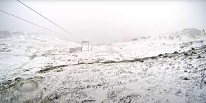
The Thredbo weather cam shows fresh snowfall on Friday morning.Thredbo
Sydney is set to reach 31 degrees on Friday with slight winds and a near-zero chance of rain,reflecting a hot and humid trough that’s moving down from Queensland.
“The heat in south-east Queensland and north-east NSW has high humidity,” said James Rouse from Weatherzone. “[It’s] making for very warm mornings and it’s making it feel hotter than it is.”
But further south,in Thredbo,snow is falling as the south-east of the state experiences an Antarctic-driven cold snap resulting in temperatures “very cold for this time of year”,Rouse said.
“The air on the surface is not from Antarctica,but the air five or six kilometres above the ground is,” he said. “It’s producing strong winds that make it feel several degrees colder,along with thunderstorms and showers[making it feel even colder].”

These swimmers at Bondi Beach were cool,calm and collected as they started yesterday soaking in the early morning rays of the sun on Thursday.Oscar Colman
The stark contrast in extremes is being driven by two competing weather systems – the trough over the north-east and the low coming from Antarctica – as well as the impact of geography. Colder air moving from the west falls as it heads over the Great Dividing Range,which heats the air as it moves further to the coast.
It results in the odd outcome that some towns on the western side of the range are relatively cooler than those on the eastern side.
The heatwave across the state is due to last for about a week,with top temperatures staying in the high 20s until Thursday.
The heatwave also has Queensland’s energy authorities on high alert ahead of an expected record usage of power in the state.

Queensland’s Energy Minister Mick de Brenni said authorities were expecting “record demand” for electricity on Friday but they believed the infrastructure would hold up.
“People using air-conditioners throughout the course of the day are going to see increased levels of demand and pressure on that system,” he said.
“The energy system is a big beast. We’ve got a lot of people working on it,a lot of parts of the system. If they all do their job today and perform well,the lights will stay on.”
The Morning Edition newsletter is our guide to the day’s most important and interesting stories,analysis and insights..