Shag Rock,we always called it.
Cormorants,also known as shags,regularly perch together on the rock for their ritual plumage-drying,with wings extended,after diving for their dinner.
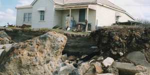
Homes in south-west Victoria were destroyed when the sea reclaimed the land.Courtesy of the Vern McCallum Collection
Somehow Google got the idea – perhaps from a well-intentioned tourism booster – that the feature is called Mermaid Rock,and that’s the dreamy name it has been given on Google Maps.
A very long time before Google Maps came along,however,Shag Rock held an important place in my family’s history.
The old people in the 1800s used it as a guide to the tides.
They had a farm on the south-west Victorian coast which required them,whenever they took an excursion along the beach by horse-drawn buggy or wagon into the only town thereabouts,to cross a river where it flowed into the sea.
In the absence of a bridge,the river mouth was impassable at high tide,but could be forded with relative ease when the tide was low and the seawater did not flood in.
And so,when they were done visiting friends or shopping in town,my ancestors took great interest in Shag Rock as they plodded homewards.
Was the sea level visibly high on the rock and getting higher,or was it receding?
They learned to calculate what the tide was doing,and thus,what the river mouth would look like when they reached it an hour down the track.
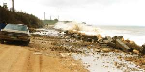
The coastal damage during heavy seas in 1994.Courtesy of the Vern McCallum Collection
The rock was both tidal chart and clock.
My ancestors would time their trek to reach the river at the lowest ebb of the tide.
Whenever I pass Shag Rock these days,I pay attention for another reason altogether.
I study it to judge whether a rising sea is beginning to engulf the ancient stone guidepost standing out in the water,left there about 36,000 years ago when a river of lava from a volcano cooled and solidified.

Happily,it still stands above water when the tide is gentle,still offering a dry roost for shags,who suffer the indignity of having been lumbered with feathers that are not as waterproof as other seabirds.
For how long might the rock remain a reliable guide,I wonder,a touch nervously?
There is reason to worry.
As anyone must know from paying even vague attention over the years to the work of climatologists,oceanographers,coastal erosion experts and practitioners of all manner of related sciences,the sea is on the rise,whatever denialists might wish.
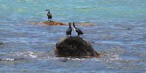
Cormorants on Shag Rock near Portland.Allen McCauley
Only this week,The Age revealed the of the Victorian government’s Port Phillip Bay Coastal Hazard Assessment.
Beaches,homes and infrastructure all around the bay are judged at serious risk of inundation over the coming decades.
Almost five square kilometres of central Melbourne alone is at peril of sea level rise of 1.4 metres by 2100 and in one-in-100 year weather events. Docklands,Southbank,Fishermans Bend – underwater!
Multibillion-dollar challenges lie ahead for bayside communities all around the bay.
And so,over a decade or so,I bore witness to what now is anticipated to be the future:the inundation of vast coastal areas through rising sea levels.
The government,clearly alarmed at the implications,has only now released the report and its unnerving maps – six years since the assessment was commissioned.
If sheltered Port Phillip Bay is in such danger,what of the rest of,and that of,?
It happens I witnessed,a long time ago,a first-hand preview of the future.
It was brutal and ugly.
During the 1960s,down the coast a bit from Shag Rock,the sea began to reclaim the beach on which my brother and I,and plenty of neighbours and friends,had played happily for years.
It wasn’t exactly a matter of climate-driven sea rise,which we will explain,though it was caused,like climate change,by human behaviour.
The effect,however,was precisely what is promised to lie ahead now for many coastal communities.
Our wide and lovely beach was nibbled away.
Dunes began to disappear as high tides assaulted them.
Soon enough,houses were teetering where land met water. The first house to fall into the sea was undermined during a storm that came with a king tide one dark Easter night.
Homeowners close to what had been a glorious beach faced a distressing choice:hoist their houses onto the back of trucks and haul them inland,or abandon the place and wait for their dreams to fall into the sea.
With the sound of the ocean tearing ever closer to our home,turning nights into nightmares,my family and those neighbours who remained were saved at the last minute,though the beach was gone.
Giant trucks called Euclids came bearing loads of big basalt stones. Load after load was dumped on the shore,creating a long and high rock wall.
Ever since,the sea’s will to surge inland has been frustrated,its energy smashing itself against our stone wall.
Further along the beach,however,where the wall stopped,the sea proved voracious. Streets and whole blocks of seafront land disappeared.
For years,steel pipes reared above the waves a hundred metres from the shore. Here were the casings of bores sunk by householders – the only evidence that the sea had gobbled house blocks away.
Every storm for years beyond caused more damage,until the stone wall was extended,only to imperil the beaches beyond.
It was,as mentioned,not a matter of climate change,at least at the start.
It was caused by disastrous planning approved by Victorian and local authorities in the 1950s.
The Portland Harbour Trust,established by the Victorian government,was permitted to enclose the Port of Portland with long breakwaters built of rock.
Erosion after a storm near Portland.Courtesy of the Vern McCallum Collection
When the biggest breakwater,the K.S. Anderson wharf – designed to harbour ocean-going ships – was opened in November 1960,The Age declared it “the greatest day since the first Henty landed”,referring to the beginning of European settlement in Victoria in 1834.
But the wharf,unseen,was trapping behind millions of cubic metres of sand that previously had swept around the coast to replenish the beach upon which my family and numerous others lived.
It was a human-made disaster,this starving of the coast of its sand. But no authority revealed for many years how or why it happened.
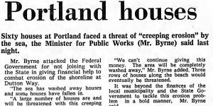
The then Victorian minister for public works,Murray Byrne,explained it away as late as 1971 as “creeping erosion” caused by “abnormal high tides and storm conditions”.
It was,in fact,all because the CSIRO’s principal research scientist in 1956 made a fundamental error. Testing the course expected of sand drift,the scientist arranged for tonnes of rutile tailings – a material easily traced – to be dumped into the sea to mimic the way sand could be expected to travel.
Problem was,the rutile material was of both a different shape and a different density to local sand,which rendered the experiments all but useless.
How The Age reported a threat to homes in Portland in 1971.The Age
The river of sand that had traditionally replenished our beach and beyond did not follow the route tracked by the rutile tailings,and piled up behind the new wharf.
And so,over a decade or so,I bore witness to what now is anticipated to be the future:the inundation of vast coastal areas through rising sea levels.
We are,of course,already seeing the beginning of that future along great stretches of our coastline.
Five years ago,The Age’s Royce Millar reported the that “key sections of the Great Ocean Road are at risk of being washed away,raising safety fears and calls for the Andrews government to reroute parts of the world-recognised tourist road”.
Things haven’t improved since.
In late 2022,The Age’s Benjamin Preiss that at “Eastern View near Fairhaven,between Aireys Inlet and Lorne … Victoria’s Environment Department is preparing to build a rock wall to guard against the erosion despite concerns rigid structures can worsen the problem and might even result in the beach disappearing underwater at high tide”.
Meanwhile,the past year has been the world’s,according to Europe’s top climate agency,Copernicus.
The Earth was 1.48 degrees warmer than pre-industrial times,barely less than the 1.5-degree limit set under the 2015 Paris Climate Accord as.
One of the most catastrophic consequences of the changing climate,of course,is forecast to be rising sea levels as polar ice caps and glaciers melt.
What to do?
I shall remain as attentive of Shag Rock – tidal chart and clock – as were my ancestors.
The rock will tell us – and the cormorants,who will have to find another perch – when the future is here.
A new online tool developed by the Bureau of Meteorology pinpoints how the climate is changing in each suburb.
Get to the heart of what’s happening with climate change and the environment.