Atmospheric oddity reveals its secrets over Port Phillip
Melbourne physicists have cracked the secret of an eerie cloud formation that rolls across north Queensland’s gulf country on moist spring mornings and occurs very occasionally on Port Phillip Bay.
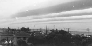
A rare roll cloud over Port Phillip Bay on 6 January 1984.Dr Bill Physick
Roll clouds — known as “morning glory clouds” to residents of the gulf — typically occur in the form of a cylinder,or a series or parallel cylinders that can stretch from horizon to horizon,moving rapidly through still air.
The gulf’s morning glory cloud is the most frequent and famous roll cloud In Australia. It appears in the east on calm,moist spring mornings and travels silently across the flat country at speeds up to 60 kilometres an hour.
Scientists at the CSIRO’s division of atmospheric research at Aspendale photographed a similar phenomenon at Port Phillip Bay on 6 January 1984. Then,a series of roll clouds came in low across the bay towards the city around 9am.
Dr Bill Physick,who took the photographs,said the cloud was an example of a gravity current. Its movement was illusory — it reflected the passage of a wave of energy at the interface between two different fluid layers,like a ripple passing across the surface of a pond.
The latest edition of the CSIRO’s environmental research magazine,‘Ecos’,describes research into the gulf country’s morning glory cloud by a team of Melbourne scientists. The cloud,it says,results from an unusual interplay of geography and meteorology over Cape York Peninsula,and is set in motion by the “breathing” of the air mass over the peninsula.
In October,when northern Queensland’s skies are particularly clear,the tropical sun heats the elongated land mass of Cape York,causing hot air to rise. Cool air is drawn rapidly from both sides of the peninsula and moves inland like the foam ahead of a wave. Around midnight,the two air masses collide head-on over the long axis of Cape York,creating an enormous,elongated mound of turbulent cool air that sinks under its own weight,driving two gravity currents — one east over the Coral Sea and the other west over the Gulf of Carpentaria.
The east-moving gravity wave apparently is dissipated by steady winds over the sea. The westbound wave rides over the gulf country on top of a stable layer of cool,relatively moist air about 1000 metres deep. This cool air mass is preceded by an invisible bow-wave of energy,which sets up a single wave or a series of parallel undulations In the moist air mass beneath.
The peak of the undulation may lift moist air to a height of several hundred metres,causing its moisture to condense out as visible cloud before it subsides again. In this way,the morning glory cloud appears to roll across the landscape.
Dr Physick,who visited the gulf country in 1982,described the morning glory cloud as “the most remarkable thing I have ever seen in my life. It’s white and grey aid looks like it has been formed inside a cylinder. It seems to rotate backwards”.
He said similar gravity waves were probably not uncommon in other areas of Australia,but if their boundary layer conditions were unsuitable,they probably remained invisible. They were,however,sometimes seen on Spencer Gulf in South Australia and Port Phillip Bay in Victoria.
Roll clouds are of more than pure scientific interest. The article in ‘Ecos’ says they could endanger aircraft during take-off or landing.