Behind Kyne,a team of exhausted locals had gathered around the local pub,their hands covered in sand,trying to drink its kegs dry. Everyone was anxious. No one knew what the coming night would hold.
The town had been hammered by hours of rainfall,with more along upstream catchments of the Campaspe River,the brown serpent that bisects the town. As we stood there,those creeks and gullies were dumping the rain into the river. The serpent was starting to swell.

“We’re all very anxious”:Tracie Kyne in Rochester’s main street.Jason South
Everyone knew the river would breach its banks. The gnawing question was:how high would the waters rise?
The Bureau of Meteorology had initially,well below the 2022 flood peak that inundated nearly the entire town. Ordinarily,that would be a somewhat reassuring figure,with just a few dozen homes at serious risk.
The problem,Kyne said,was no one here trusted emergency authorities to get flood predictions right. Not any more.
“In 2011 and 2022,they underestimated the levels that we actually received … 2022 was a lot worse than they told it was going to be – all us were unprepared,” she said.
In 2022,Kyne said she was told that her house wouldn’t go under water. It did.
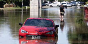
Floodwaters in Rochester in 2022.Justin McManus
Emergency services also underestimated flood peaks in 2011.
Complaints about late or inaccurate warnings aren’t confined to northern Victoria. Some locals in towns north of Cairns flooded by say they only got flood warnings at 9am – when they were already standing on the roofs of their flooded houses.
“No shit,we’re in it,” one local toldThe Cairns Post. That prompted the federal government to launch a review of the Bureau of Meteorology’s warning systems.
And then there’s the big El Nino question:where is it? Some farmers say they panic-sold their livestock,expecting a hot,dry summer after. Yet November was wetter than average and December and January have been marked by floods.
‘Better than ever’
Is it possible that the Bureau of Meteorology’s ability to forecast the weather is waning?
The bureau rejects this suggestion out of hand. “The Bureau of Meteorology’s forecast accuracy has consistently ranked in the top 5 in the world[by the World Meteorological Organization],” a spokesperson said.
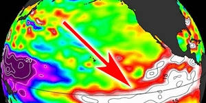
El Nino events typically have a big impact on Australia,bringing worse droughts and bushfires. Extreme El Ninos are projected to increase in number as the planet heats up.NASA
Based on,it says 91 per cent of its forecasts for temperature are accurate to within 2 degrees. The vast majority of the rainfall forecasts are accurate,and in 2022-23,some 85 per cent of their flood peak forecasts were accurate to within 0.3 metres.
They even have a tagline:“Our seven-day forecasts today are as good as a four-day forecast was in the 2000s.”
None of the independent scientistsThe Sunday Age spoke to held any concerns about a decline in forecast accuracy. On the contrary,most said the Bureau of Meteorology was becoming more accurate.
“Weather prediction has become much more skillful over the past few decades. And that’s quite a big increase – particularly from the ’70s and ’80s onwards,” said University of Melbourne researcher Dr Andrew King,who specialises in predicting climate extremes.
“I think a lot of people don’t realise just how far weather prediction has come.”
Indeed,several experts characterised the fact we have accurate forecasts at all as something of a scientific miracle. Until the past few centuries,we relied on “weather lore” like the biblical proverb to watch the sunset’s hue for clues about rain the next day.
“The fact we can forecast the weather is pretty astonishing – it’s a major scientific achievement,” said Monash University meteorologist Professor Michael Reeder.
Modern forecasting is computer-driven. Satellite and weather-station observations of the atmosphere are fed into a computer model that is run somewhere between 10 and 50 times – each model given a slightly different set of observations – which then run on supercomputers.
The models’ predictions are combined to give a forecast,with variation between the models providing the range of uncertainty.
Three key factors have improved accuracy:more satellites in the air means more fine-grained observations of the Earth’s atmosphere;more teraflops of supercomputing power means more modelling;and better mathematical techniques allows for more accurate model atmospheric dynamics.

Weather observer Michael Glasson releases a weather balloon at Giles weather station in Western Australia to track wind speed and direction. The data will help predict rain in Sydney .Steven Siewert
Yet weather forecasts remain less than perfect. That inaccuracy is because scientists cannot know the location of every single particle in a weather system,and by the inherently random nature of weather.
“There is this stochastic (random) part of the weather,which you’ll never get around,” said Reeder. “But we’re definitely getting better,we’re better than we ever were.”
Predicting the unpredictable
So what explains the Bureau of Meteorology’s recent high-profile misses?
The bureau is proud of its ability to accurately forecast daily temperatures. But getting maximums and minimums right is far less important to many people than nailing the extremes,like the exact location of heavy rainfall. And these extremes are much more difficult to predict.
“They are often quite small-scale – a few kilometres wide. Especially more than a few hours in advance,it’s really hard to forecast exactly where these events will occur,” said King from Melbourne University.
Because you’re dealing with extremes,small inaccuracies in the data fed into the forecast models are likely to have much bigger effects.
And many extreme weather events are driven by multiple weather conditions compounding each other,says Dr Martin Jucker,who teaches atmospheric science at the University of NSW.
The was caused primarily by a low-pressure system dumping water onto the coast of northern NSW. Low-pressure systems typically move across the atmosphere,spreading the rain – but this one was pinned in place by a high-pressure system sitting over the Tasman Sea. “So it just kept raining without moving away. That made a rainy system into a multi-day flooding event,” said Jucker.
Lismore after the 2022 floods.Natalie Grono
Errors in predicting either a low-pressure system or a high-pressure system could introduce inaccuracy into the overall forecast.
Then there’s the climate crisis,which compounds the existing issue. Global heating:more extremely hot days,more sudden heavy downpours.
Dr James Renwick,a weather researcher based at the University of Wellington in New Zealand,said:“Accurately predicting extremes is always harder than predicting closer to average conditions,so in that sense you could say things are becoming harder to predict.”
Others are sceptical of this hypothesis. Monash University’s Reeder said:“We would expect things to change a bit – but I don’t think anyone is expecting things to change wildly.”
A modelling study published inin 2019 concluded that the long-term effects would be complex:accurately forecasting temperature in a warming world might get easier,but the accuracy of summer rainfall forecasts could fall.
But that study “is talking about what may happen in 50 years,not what’s happening now,” said Reeder. “The effects they describe will be tiny in the current climate.”
The Bureau of Meteorology itself is even-handed. “It will take time to evaluate and understand the data to determine the impacts of a warming climate on forecast accuracy,” a spokesman said.
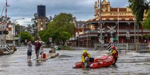
Rochester flooding on January 9.Jason South
All these are technical problems that may introduce inaccuracy. But there’s the human factor. The Bureau of Meteorology can forecast one thing – but what people hear can be quite different.
Throughout 2023,attention was focused on steadily rising surface temperatures in the central and eastern Pacific Ocean,and the flagging equatorial trade winds. Combined,:the most feared of Australia’s climate conditions.
Europe had just sweltered through a. Atmospheric carbon was pushing past 419 parts per million. And just about every global weather agency bar the Bureau of Meteorology had declared an El Nino by July.

That led to intense public and media focus when the bureau finally did announce in September that the Little Boy was coming. Farmers,fearing drought,panic-sold their livestock. By November,the price of cattle had fallen from $7 a kilo to $1.40;the value of Australia’s national herd more than halved,the sharpest price fall in decades. Some they couldn’t sell.
Even Dr Linden Ashcroft,a climatologist at the University of Melbourne,got swept up. “Even with 10 years of experience,thought uh oh,we’re in for another hot dry summer.” But El Nino does not automatically mean bushfire and drought. “It has its biggest impact in spring,but then it decays in late summer,” said Ashcroft.
Indeed,August to September was the driest three-month stretch in Australia on record and spring rainfall was 20 per cent below the long-term average,while temperatures were the fifth-warmest on record. And the actual summer forecast in November suggested a warm summer,but not an extremely dry one.
“I’m not sure if it was a communication failure on the Bureau of Meteorology’s point of view,” said Ashcroft. “Maybe that nuance is something we as a nation need to get our head around.”
The bureau,for its part,believes its communication was clear. “Around half of the past El Niño events have included heavy rainfall events,particularly across parts of eastern Australia,” a spokesman said. “No two El Niño and IOD events are the same.”
A wet,wild future
Even if the bureau is able to accurately forecast wild weather,it’s still going to happen. As the world warms,extreme weather events are going to happen more and more.
Global heating isn’t just about heat – it’s about energy. There is more energy in our weather system and so everything is more extreme:heat,rain,storms,cyclones. Overall,Australia is seeing less rain – up to 19 per cent in some regions –.
This raises an existential question for towns like Rochester,founded in an era of far more temperate weather.
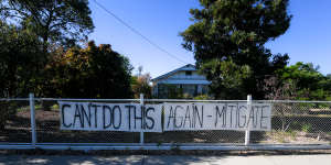
A message from Rochester residents in October 2023.Justin McManus
“There are so many towns around Australia that are similar to Rochester,” said Natural Hazards Research Australia’s chief executive,Andrew Gissing. “Given the size of their flood risk,they are difficult to protect. It’s not like you can put a levee around them and they are all good.”
Rochester needed infrastructure to manage river flows,and the town’s homes needed floodproofing,he said. “It’s like designing your whole home like it’s a bathroom.”
But for some towns,like Lismore,that “just get flooded and flooded,and people live in a constant state of recovery and they can’t afford insurance”,it might be time to accept people simply could not continue to live there,Gissing said.
On Tuesday morning,after a sleepless night in Rochester’s caravan park,Janine Cole and Peter Mann were out to visit their riverside bungalow. Their garden had vanished under floodwater,which luckily hadn’t made their way inside the house.
They,like much of the rest of the town,could breathe a sigh of relief – the flood warnings had slightly overestimated the river’s peak. But even if the flood had made its way inside,there wasn’t too much damage.
Cole walked past a “Restricted Area:Do Not Enter” sign to open the front door,revealing floor joists over brown mud. Her house still hadn’t been repaired after the 2022 floods.
“This is all[the insurers] have done,” said Cole. “We were supposed to be in the bungalow by Christmas. But the plasterer quit. And they couldn’t get a[replacement] plasterer. And just everything happened.”
For many locals,two floods in 15 months – three in 13 years – will simply be too much,says Leigh Wilson,chair of the local community recovery committee. The Victorian government isn’t yet talking about buybacks,but people will vote with their feet.
“There are people that have just managed to hold themselves together. This will be too much for people,” said Wilson. “They will need to leave.”
Get the day’s breaking news,entertainment ideas and a long read to enjoy.